Fisheries
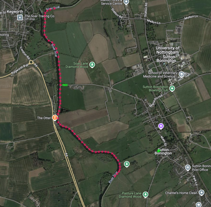
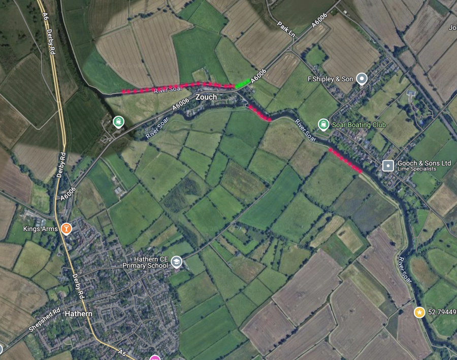
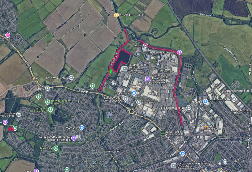
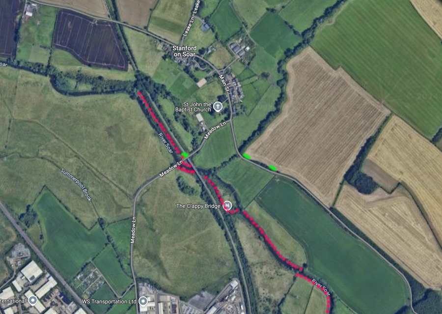
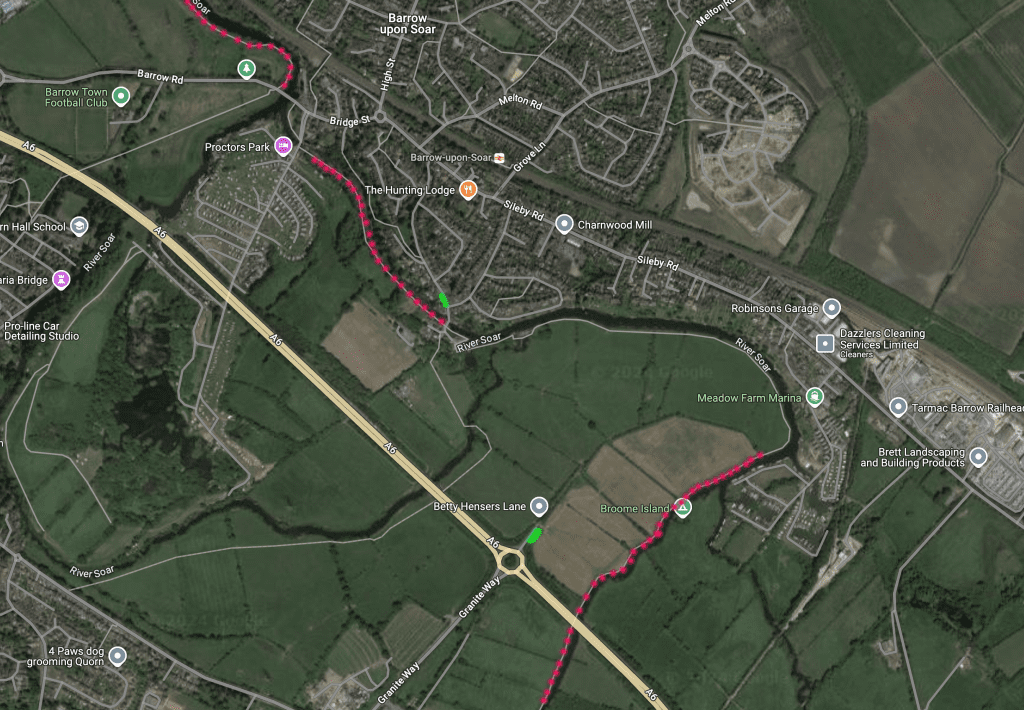
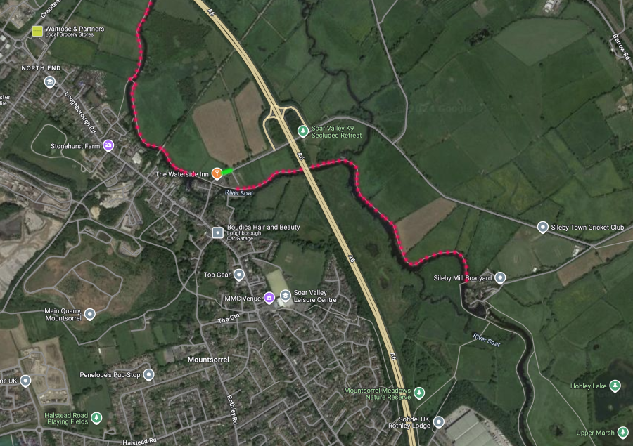
See the maps at the bottom of this page for precise details of each water. The red dots signify our fishable water, the green dots show where to park.
Stillwaters
Dishley pool
what3words parking location ///join.slams.shots
Park in the car park adjacent to the playing fields, note the barrier may locked between dusk and dawn by the council.
Situated on the outskirts of Loughborough next to Derby Rd playing fields, access via Cotton Way and park next to the playing fields adjacent to the brook. Note that the council may lock the gates from dawn to dusk
Stonebow Pool
what3words parking location ///compiled.alerting.whiplash
Park on Lindisfarne Drive with respect to local residents.
A small settling pond adjacent to the Black Brook which holds a good head of smaller fish including rudd, roach, perch and tench, ideal for kids or just a fun days fishing.
Canals
Kegworth canal
what3words parking location ///creatures.sucesses.winded
Park on Soar Lane.
From Kegworth deep lock to it’s junction with the river heading towards Sutton Bonington
Zouch canal
what3words parking location ///recorder.unlocking.baker
Park on the verge.
From the road bridge near the weir to Zouch lock, towpath bank only
Loughborough canal
what3words parking location ///hope.ladder.swept
Park on Swingbridge Road.
From it’s junction with the Soar near to Dishley Pool up to Loughborough lock which is the second lock along.
Barrow canal
Access at what3words location ///magically.sushi.vaccines please park with respect to local residents
From the bridge near the Navigation pub along the towpath to the lock near Proctors park.
River Soar
Sileby boatyard to the Waterside pub
what3words parking location ///drawn.lamplight.bracing
Park sensibly on the verge, please note that we have no agreement with the pub regarding parking on their land.
From the footbridge crossing the river below Sileby weir downstream to the Waterside Inn at Mountsorrel, there is very limited parking on the lane heading into Sileby marina.
Mountsorrel 1860
what3words parking location ///drawn.lamplight.bracing
Park sensibly on the verge, please note that we have no agreement with the pub regarding parking on their land.
From the end of the no fishing area just downstream of the Waterside Inn to the footbridge crossing the river and then on the opposite bank to the A6 bridge.
Betty Hensors lane
what3words parking location ///forces.savers.whisker
From the A6 bridge to near to Barrow marina. Note the private fishing sign beyond our water.
Barrow Deeps
what3words parking location ///ramp.deranged.sweated
Accessed from Flesh Hovel Lane, park in the club car park at the bottom of the field through the locked gate, the code is on your permit.
From the bridge on Barrow Road downstream to Pillings lock.
The Osiers
what3words parking location ///ramp.deranged.sweated
Accessed from Flesh Hovel Lane, park in the club car park at the bottom of the field through the locked gate, the code is on your permit.
From Pillings weir downstream to the bombhole, the end of which is marked by a fence.
Bonsers and the old weir
what3words parking location ///market.movie.robots
Park in the club car park you risk getting a ticket if you park on the verge.
Walk back towards Loughborough and look for a gateway on the opposite side of the road approx 50yds along. The fishery starts just past the 90 degree bend in the river and finishes at the weir pool upstream.
Abbey Meadow, 20 acre and Prayer meadow
what3words parking location ///market.movie.robots
Park in the club car park through the locked gate, the code is on your permit, you risk getting a ticket if you park on the verge.
Downstream of Cotes road bridge, the first field is Abbey meadow, second one 20 acre, third Prayer meadow.
Brickwoods
what3words parking location ///clips.rooms.inch
Park in the layby on the Loughborough side of Cotes bridge.
Upstream of Cotes road bridge on the bank nearest to Barrow, opposite Bonser.
Gorse meadow and Navvies cutting
what3words parking location ///badly.hosts.drift
Park on the verge along Stanford Lane.
Cross the field to the footbridge, Navvies cutting is across the bridge fishing from the island. Gorse meadow is upstream before you cross the bridge though a small gate.
Eleven Arches
what3words parking location ///fails.farms.passes
Park sensibly in the club car park or under the bridge, spaces are limited.
Upstream on both banks to the railway bridge, downstream on the railway bank to the fence end.
Kettle Brook
what3words parking location ///join.slams.shots
Park in the car park adjacent to the playing fields, note the barrier may be locked between dusk and at dawn by the council.
A small stream running adjacent to Dishley Pool, from the A6 road bridge to it’s junction with the river.
Zouch
what3words parking location ///recorder.unlocking.baker
Park on the verge.
Walk across the two bridges over the weirs, we have the first field and the fourth field which is opposite the pub.
Sutton Bonington
what3words parking location ///creatures.sucesses.winded or ///bitters.repeating.disgraced
Park either at Soar Lane or Sutton Bonington playing fields.
From the gate at downstream end of devils elbow island (visible on the far bank) up to Kegworth canal.
Sutton Bonington and Kegworth Canal
Zouch
Stonebow and Dishley Canal
Eleven Arches, Navvies, Cutting Gorse Meadow
Cotes, Bonsers and Brickwoods

Osiers
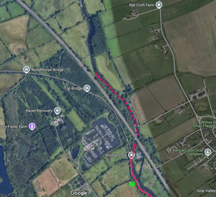
Barrow Deeps
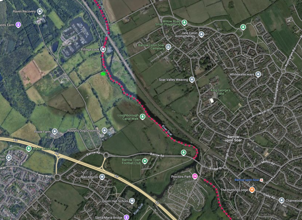
Barrow Canal & Broom Island
Sileby Waterside & 1860
For Match Bookings Call 01509 502970
or Email: loughboroughsoar@gmail.com
Follow us on Facebook
